Let me get this little disclaimer out of the way up front - the trek I'm going to describe is not an accessible trail using any known definition of "accessible." There is no "flat" or "paved" involved.
That being said, however, I was more determined than ever to make it to the summit of 2,517' Mission Peak. I know it's a grind to the top from the Stanford Avenue parking area in Fremont. Friends told me, though, that the trail from Ohlone College was "easier."

"Easier," I thought, wondering if using any derivative of "easy" was appropriate for this hike. I would find the answer is "no"but the trip up from the College offers an incredible series of changing landscapes and the accompanying views. Let's talk a bit about the trail.
I rolled into Ohlone College one Sunday morning on a cool weekend - cooler, anyway, than our dear departed summer. A shroud of low cloud cover moved in over the peak. I was a little emotional - I had ordered a new trail chair and was putting my trusty steed of the last three years to rest after this hike. We'd been through a lot, the two of us, but my dear chair was losing its frame integrity, as the numerous welds on parts that had fought my fight with me bear witness.
So it was that day - an intrepid adventurer on a farewell tour. I rolled over to the trail-head and gazed up at what had looked like a fairly simple grade from 4 miles away. The closer I rolled, the steeper it got. This mountain has some volume, I thought. My first challenge! I was off, straight up a short, steep connector to the main trail. I stopped to rest as the trail opened up, and took note of the landscape. Dry grass for miles, it appeared, typical Fall in the East Bay hills. The west side of Mission Peak looks very much like any grassy terrain common here in this time of year. I'd resigned myself to that, expecting a long featureless test of wills until I cruised to the top. How wrong I was!
Instead, I discovered a new member of my personal "Top 10 EBRPD Hikes". This trail seems to be a favorite of
mountain bikers as well as hikers. Unlike the gravelly surface from Stanford Ave., the rock on this trail is
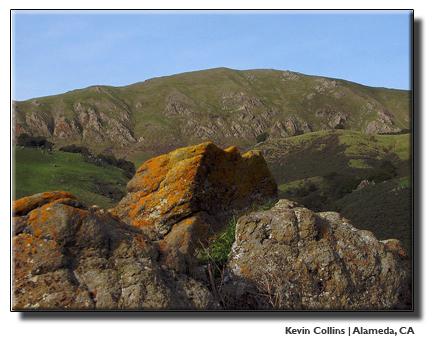
embedded and pokes up from beneath. The surface provides obstacles, which I enjoy, as well as places to park amongst the rocks. The best features of the route are unexpected after looking at all the dry grass on the west side. There are trees and shade, canyons lined with oaks hiding many of my favorite birds - hawks, kestrels, wild turkeys and others. Ground squirrels were out in force, perhaps sensing an early and long winter. I'll let you know how they stack up against our TV weather forecasters when spring arrives but I trust the animals to be accurate more often than not. And the animals told me "cool and dry" for their off season.
Mission Peak's viewpoints seem to recharge at even the slightest rise in elevation. Look over the Bay - photo op.
Turn 90 degrees south - photo op you get the picture - the scenery is as varied as the angle at which one stands, or sits. Many points seem perfect for the landscape painter who doesn't mind a bit of a workout to get to their perch. I rolled slowly over the decomposing sandstone and slabs of serpentine. Jagged points set rigidly in the hard dirt poked menacingly up toward my tires. It became quite a game to fit the wheels through narrow spaces between rocks in order to keep the tires pressurized. If you're on a bike, be careful. Ruts and rocks and poking things are what this trail is made of - and it's delightful.
But knowing the western slope trails as I do, I had revved up for a good workout on a continuous grassy slope. As I
turned up a fairly steep stretch toward what appeared to be a flat (thank my perceptions, it was), I felt a burst of energy as I engaged the dirt, and we battled - the surface trying to buck me, and me nonchalantly cranking it up, chuffing over uneven patch after patch. I stopped at the flat to look back on the section, and was pleased that I could still beat up such a challenging section. The trip down would be easier.
It was on this stretch I heard a voice call my name, and saw EBRPD Bicycle Safety Patrol Volunteer Ted Stroll
chugging up the trail. He and fellow Trail Patrol Volunteer Ben Yee know every nuance of Mission Peak, and have
provided a sense of comfort to hikers and more casual visitors to the park. Their knowledge of the area is
unparalleled, and Ted was kind enough to offer some advice about potential alternate routes for me. I was grateful,
and when I got home I marked my map with some of his suggestions. We parted company as he worked his way up the
trail toward the summit.
Taking advantage of a shallow downhill, I was startled to find that the trail was narrowing to single - track width. Most surprising was a forest of oaks and laurels cradling the trail as we followed the shoulder of a seasonal (now dry) creek. There was shade here for those hot days, as well as natural umbrellas offered by the trees in denser places. Vines and bushes, grasses and trees if you're used to Stanford Avenue Staging Area as your take off point, this stretch is quite the surprise.
The tree lined path probably lasted little more than a few hundred yards, yet at my speed I was able to savor the
sounds and aroma of the lush vegetation. Dang, I thought I could sit here all day if I could sit still that long.
Negotiating a narrow, slippery part, I reconnected with the more familiar fire road style trails that run through
the park. But what an interlude! All the hard work to this point was forgotten. I began hoping for some dry time
over the winter so I could do this when it was cooler but not muddy.
The fire road instantly turned "up", and I took note that my hands were getting blistered. They were in decent
enough shape to plow forward for awhile, but I had stopped thinking I would summit today. Besides, I wanted to be
able to brake on the way down - that would be a good thing, right? Rather than labor up to the top of Mission Peak,
as I'd done a few times before, I stopped where the trail from Stanford Ave intersects. Kestrels darted through the
air at high speed on the northwest slope of the peak, and streams of people determined to summit pushed past me,
their smiles telling me the grind up was worth the effort. This is a steep trail. But making it to the top of
Mission Peak is worth a few photos and some celebration. There were plenty of both at the summit this breezy Sunday.
Not to be anticlimactic, but I rested for a bit and dressed my blisters while taking in the views of Sunol - Ohlone
Regional Wilderness to the southeast. The rewards of this hike can be broken out in a thousand directions - the
effort, sights, sounds, smells and camaraderie with other hikers made this hike a "grinner". Every time I make it
out here I want to keep going, to head down the back side into Sunol, or south through the saddle to Monument Peak,
which makes for a real long but rewarding day. Even while pondering the summit, possibilities open up. Easy to see
why Mission Peak is a favorite of mine. Make your way here and walk, run, bike or hang glide around. Be sure to pick
a spot that pleases you, then close your eyes and listen as Mission Peak speaks to you. Its voice will, as it has
with me for years, call you back. Answer the call, because you'll find the park amazing.


