Multi-Use Open Space Roads & Trails
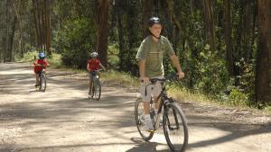
Mountain bikers can enjoy non-paved dirt or gravel fire roads that are 8’ in width or greater throughout most of the East Bay Parks. Mountain bikers are welcome to ride on certain multi-use trails less than 8’ in width by exception. Multi-use roads and trails are shared with hikers and equestrians. Check each individual park maps for which trails are accessible by mountain bikes.
Natural Surface Trails
Natural surface trails are generally pedestrian or pedestrian and equestrian hiking trails or footpaths throughout the parks and typically do not allow bikes and in some cases do not allow equestrians. There are a few exceptions where bicycles are allowed on natural surface trails. These exceptions can be found in Attachment A of Ordinance 38.
Mountain Bike Top Picks
With over 800 miles of dirt roads and approximately 50 miles of natural surface trails that allow bikes, choosing the appropriate off-road biking route isn't always easy. To find a bike accessible trail in a park near you, check out the Park District’s Bike Loop Brochures below.
Thanks to the East Bay Regional Park District staff and Volunteer Trail Safety Bike Patrol, here are some of the best trails for different levels of ability:
Beginner - Entry Level (good for new mountain bikers, fairly level terrain)
- Quarry Lakes in Fremont - Trails are all level graveled surfaces; 4-5 miles of trails all accessible for bikes, connects to Alameda Creek Trail which is paved on one side, gravel on the other. Bikes can ride on either side of Alameda Creek Trail
- Point Pinole in Richmond - More than 12 miles of mostly flat or gradually sloping dirt or gravel trails. There is one asphalt trail about 1.5 miles long from the parking lot to the pier. Bikes are permitted on the pier, which juts about a quarter mile into the San Pablo Bay. Lots of loop options from the asphalt trail but beginners may want to stay on the East side of the park on Marsh Trail and Cook's Point Trail. The West side trails such as Bay View Trail are slightly more rolling along some fairly steep cliffs. More advanced riders will enjoy the challenge and views on this side.
- Diablo Foothills in Walnut Creek from Castle Rock Staging Area - This 1-mile-long trail is perfect to test out skills on rolling hills, through creeks, and shaded woodlands. Riders will likely encounter lots of horses so be polite when sharing the trail. The trail ends at Mt. Diablo State Park. Cyclists can continue into Mt. Diablo but the trail begins to climb pretty quickly.
- Lake Chabot Paved Path with Trail Option in Castro Valley - This 4-to-8-mile roundtrip ride is a step up from an entry level. Older kids will love it. This section is part of the longer Chabot Bike Loop but for beginners, we suggest an out and back. Start by taking the recently repaved Eastshore Trail. It's made up of rolling hills, so watch your speed. This is good practice for changing gears. The paved trail turns to dirt. Look for the bridge on the left. Carry your bike across the bridge and resume riding on the dirt path. Be warned! Don't take the regular Chabot Bike Loop unless you want to tackle a mile long technical ride with a 1,000-foot elevation gain. You stay on the flat Honker Bay Trail which hugs the lake. This is good practice riding on a typical dirt trail. Turn around and head back when you're ready.
- Others Parks - Round Valley, Morgan Territory, Sunol (Camp Ohlone Road)
Intermediate
- Del Valle South of Livermore - This is an out and back ride that can be anywhere from 2 to 14 miles. Take the East Shore Trail from the marina which is a wide dirt and gravel road for about one mile. At the Swallow Bay trail, you can ride on natural surface trails hugging the lake. These trails require a high level of fitness but for the most part can be ridden by riders that are fairly new to the sport. There are many places one can get off of the natural surface trail in favor of the fire road if the natural surface trail proves overwhelming. The ride is long with many changes in topography and scenery. This is also one of the few places in the district that if the ride gets too hot you can cool off in the lake! No lifeguards, so swim at your own risk.
- Anthony Chabot in Oakland Hills - This 8.5-mile loop will take you through the heart of this regional park including open grasslands and shady forests. This makes a nice intermediate ride, traveling on a portion of the Chabot Bike Loop without the major hills. From Bort Meadow off of Redwood Road, ride on Grass Valley Trail, south for about 1 mile. Then turn left up Redtail Trail (east) for a little over 3 miles to the day use parking area located at the intersection of Brandon Trail and Marciel Road (where you can also park) then turn right (west) on Brandon Trail all for 4.6 miles back to Bort. It is slightly uphill on the way back. Another route, that is easier, is to stay on Grass Valley Trail and turn left on Brandon Trail to the day use parking area then return on Brandon Trail all the way back to Bort Meadow. You can also start your ride at the day use parking area.
- Reinhardt Redwood Regional Park Bike Loop in Oakland Hills - This 8.22-mile loop circles Redwood Regional Park in the Oakland Hills along the East Ridge and West Ridge Trails. Most cyclists do this loop in a counterclockwise route. West Ridge is moderately technical with rocky sections and a steep descent. Canyon Trail to get to East Ridge from the main Redwood Gate entrance is a steep uphill but the rest of the loop is fairly moderate.
- Others - Briones, Pleasanton Ridge, Lake Chabot Bike Loop
Advanced
Crockett Hills Regional Park has almost 10 miles of natural surface trails accessible to bikes. Expect some strenuous climbing to access the southern portion of the park where you will find a network of bike optimized trails including the Sugar City Trail, Warep Trail, Tree Frog Loop, Goldfinch Trail, Two Peaks Trail, and the Back Ranch Loop Trails. Please note that the Goldfinch Trail is subject to seasonal closure.
Start at Crockett Ranch Staging Area on Crockett Blvd. just south of Pomona St. Route: From the parking lot climb Edwards Creek Trail about 1 mile to Woodrat Trail. Go right and follow Woodrat Trail through the tunnel. Climb Sky Trail to Big Valley and go right. Make a quick left and ride through the trail gate onto Sugar City Trail. Please practice good trail etiquette and follow all trail rules. Bike bells are recommended and provided at the trailhead.
For more details, there is a short loop and long loop described on the Crockett Hills page of the Bicycle Loop Brochure located below.
