Overview
The former Roddy Ranch Golf Course Habitat Restoration and Public Access Plan has been adopted and is available under Project Resources at the bottom of the page.
Key Goals
- Develop a habitat restoration plan for 230-acres of the former Roddy Ranch Golf Course. Restore the highly impacted site, once filled with non-native vegetation, to a more natural environment.
- Open the site to public access with several miles of trails and restroom, parking, and drinking water facilities. The park’s primary use will be passive recreation such as hiking, biking, nature study, and picnicking.
- Create opportunities for various hands-on restoration projects involving youth and community members.
- Work closely with East Contra Costa County Habitat Conservancy to restore native grassland and wetland habitat at Roddy Ranch and the surrounding area as part of the larger future Deer Valley Regional Preserve.
Site Description

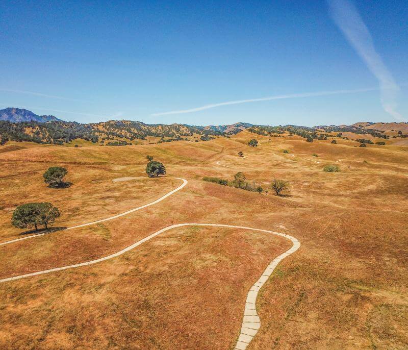
Roddy Ranch Golf Course was a 230-acre, 18-hole course located off Deer Valley Road at the south end of Antioch, CA. The East Bay Regional Park District is developing a Habitat Restoration and Public Access Plan to restore native grassland habitat and include paths and facilities for passive public recreation, such as walking, jogging, and picnicking. The former golf course property will be a part of the larger 3,700-acre future Deer Valley Regional Preserve. The planning process to open the former golf course as a park is expected to take 18 months.


History
Native people have lived in eastern Contra Costa County for millennia, subsisting on and caring for a landscape of seasonal streams, Delta waters, open grasslands, and wooded foothills. At the time of Spanish contact in the late 18th century, nearby Bay Miwok-speaking tribes included the Julpun, Ompin, and Volvon peoples. Many descendants of these first peoples continue to call the greater East Bay their home.

In 1837, American immigrant and pioneer John Marsh purchased the recently established (1835) Rancho De Los Meganos from José Noriega; the cattle ranch, at 13,000+ acres, covered much of what is modern-day Brentwood east of the future golf course. Coal was discovered in the late 1850s in what would become the nearby Black Diamond Mines Regional Preserve, and five mining towns came and went. As recently as the 1960s, petroleum was being drilled from the Brentwood Oil Field about two miles northeast of the site.
When rodeo legend Jack Roddy bought 2,300 acres of land in the 1970s, he built what would become known as Roddy Ranch, stretching from Black Diamond Mines in the northwest to Deer Valley Road in the southeast. He was dedicated to cattle grazing and philanthropy. As the popularity of golf rose and the communities of Antioch and Brentwood grew in the late 20th century, Roddy saw an opportunity to provide a public recreational opportunity. The Roddy Ranch Golf Course opened in 2000 and operated for the next 16 years, serving thousands of visitors and golf enthusiasts.
The Park District, in partnership with the East Contra Costa County Habitat Conservancy, began purchasing land that would become the future Deer Valley Regional Preserve in 2009. Jack Roddy sold his ranch to the Park District, including the now-closed golf course, in various transactions from 2014 – 2018. Due to habitat concerns and other considerations, Deer Valley Regional Preserve will remain in “landbank” status, closed to the public, for the foreseeable future. The 230-acre former golf course is anticipated to be the first part of the future Deer Valley Regional Preserve to open for public access.
» Map: EBRPD Habitat Conservation Lands [JPG]
City of Antioch-produced interview with Jack Roddy, 13m:18s
Aerial Footage of the Former Roddy Ranch Golf Course, 0m: 44s
Timeline
Project Resources
Habitat Restoration and Public Access Plan
- Habitat Restoration and Public Access Plan – Final (PDF)
- Habitat Restoration and Public Access Plan – Public Review Draft (PDF)
- Addendum to the Habitat Conservation Plan & Natural Community Conservation Plan (HCP/NCCP) EIR and Roddy Ranch Golf Course IS/MND (PDF)
- HCP/NCCP Environmental Impact Report (EIR) (PDF)
- Roddy Ranch Golf Course Initial Study/Mitigated Negative Declaration (IS/MND)(PDF)
In 2020, the Park District hired Restoration Design Group, of Berkeley, which has partnered with Nomad Ecology and other consultants to prepare the reports and planning documents needed to open the golf course as a new regional park. As information becomes publicly available, it will be posted to this section of the web page.
Existing Conditions
- Existing Conditions Report - Former Roddy Ranch Golf Course [PDF]
- Existing Conditions Report - Attachments - Former Roddy Ranch Golf Course [PDF]
Draft Alternative Concepts
- Draft Alternative – Concept A (Welcome the Wetlands): This concept focuses on maximizing wetland habitat and drainage channels by directing water to existing wetlands and by creating new vernal pool and ponds. Public access site improvements are kept to the edges and allow the open landscape to be experienced. Trails use existing cart paths where feasible to provide a shorter accessible loop and a longer loop that leads visitors through a variety of experiences. A connection to Empire Mine Road at the existing access point may provide future access to adjacent preserve and parklands.
- Draft Alternative – Concept B (Roddy Ranch Reuse): This concept prioritizes reusing existing cart paths and infrastructure to limit costs and disturbance while maximizing the value of existing features. Habitat restoration focuses on restoring the lower water drainages with minor improvements are made to each basin and pond to enhance stability and habitat. The trails follow existing cart paths to provide two accessible loops and two additional loops through the site. This alternative provides the greatest variety of routes through the site.
- Draft Alternative – Concept C (Focus on Flow): This concept focuses on improving habitat to core features by concentrating water flow to fewer wetlands. Historic water flow paths are favored in this concept to stabilize drainages and to restore the historic watershed. Where possible, outbuildings and abandoned surface infrastructure are removed. To reduce trail user conflicts, two multi-use trails are designed for uphill bike travel and are paired with flowy downhill trails optimized for cyclists.
- Draft Alternatives – Summary
- Borrador de Alternativas – en Español
Preferred Design Concept
- Preferred Concept – Map: The preferred concept focuses on maximizing wetland habitat and drainage channels by directing water to existing wetlands and by creating new vernal pool and pond features. Runoff at the top of the watershed will strategically flow along the surface and underground toward the wetlands at the base of the hills. Recreational improvements are concentrated toward the east and allow the open landscape to be experienced toward the west. A short accessible loop welcomes users at the entrance and is paved with concrete, reminiscent of the former golf course cart paths. The trail network also includes an additional accessible trail, as well as overlooks and longer earthen trails that lead visitors through a variety of experiences.
- Preferred Concept – Bird’s Eye View
- Preferred Concept – Video Overview
- East Overlook – Rendering
- Staging Area – Rendering
- Please submit your comments here
HCP/NCCP
Information about the East Contra Costa County Habitat Conservation Plan & Natural Community Conservation Plan (HCP/NCCP), including allowed recreational uses (see Chapter 5. Conservation Strategy), can be found on the East Contra Costa County Habitat Conservancy website.
Community Events and Public Hearings
- Tuesday, November 1, 2022: Board of Directors (Plan adoption)
- Monday, September 19, 2022: Park Advisory Committee
- Thursday, September 8, 2022: Board Executive Committee – Habitat Restoration and Public Access Plan
- Saturday, May 7, 2022 – public guided walks
- Saturday, September 25, 2021, 9:30am - 11:30am: Open House at Roddy Ranch Golf Course (English & Spanish) [PDF]
- Thursday, July 1, 2021: Public Meeting #2 – Draft Alternatives [PDF]
- Former Roddy Ranch: Public Meeting No. 2: July 1, 2021 >> Video
- Thursday, March 11, 2021: Public Meeting #1 – Existing Conditions [PDF]
- Former Roddy Ranch: Public Meeting No. 1: March 12, 2021 >> Video
- Monday, February 22, 2021: Park Advisory Committee - Project Update on Existing Conditions [PDF]
- Monday, May 18, 2020: Park Advisory Committee - Project Update [PDF]
Contact
Please contact Edward Willis, Planner, at ewillis@ebparks.org, or at (510) 544-2621 to be added to the project mailing list.

