Always view Alerts/Closures before heading out to parks.
Check AT&T, T-Mobile & Verizon Coverage. Select 'Map Layers' and switch on 'No Data Coverage Areas'.
View Public Transit for public transportation to the Regional Parks.
GeoPDF Maps:
You can download these FREE maps with the Avenza Maps app and use them while hiking in the Regional Parks. Your device GPS will show your real-time location on the map, even while offline. You can also add photos, measure distance or area, collect data and more. Get the app on your mobile browser: Apple App Store / Android App Store | Get a Map with Avenza | How it Works | Learn More About Avenza
Launch the app, then go to "Store" and search by Park name.
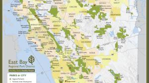
Park Maps: A | B | C | D | E-F | G-H | I | J-K | L | M | O-P | Q-R | S | T | V-W
All maps are available for download as PDFs. Read disclaimer.
Disclaimer
Maps: EBRPD makes every effort to provide useful and accurate information. The information provided is based on many data sources and represents only the approximate relative locations of features and property boundaries. We cannot guarantee that this information is correct or complete, and cannot take responsibility for conclusions drawn from this information. By using this site/maps you agree to the terms of this disclaimer.
EBRPD may link to software or websites that are owned or operated by other companies. While we endeavor to direct you to helpful, trustworthy resources, we cannot guarantee software, information, products, or services provided by third-party resources or track changes in the resource. Thus, we are not responsible for the content or accuracy of any third-party resource or for any loss or damage of any sort resulting from the use of, or for any failure of, products or services provided at or from a third-party resource. When you use a third-party resource, you will be subject to its license or use terms, and its privacy policy and security practices.