
Overview
5am to 10pm
Parking: No fee | Dog: No fee
No street address. Main trailhead is on Stonewall Road, off Claremont Ave., in Oakland.
Park Entrances: Stonewall Panoramic Trailhead (No Parking Available)
(510) 544-3112
Toll Free: 888-EBPARKS (888-327-2757), option 3, extension 4516
Internet & Cellular Access

Check AT&T, T-Mobile & Verizon Coverage.
Select 'Map Layers' and switch on 'No Data Coverage Areas'
Park Activities
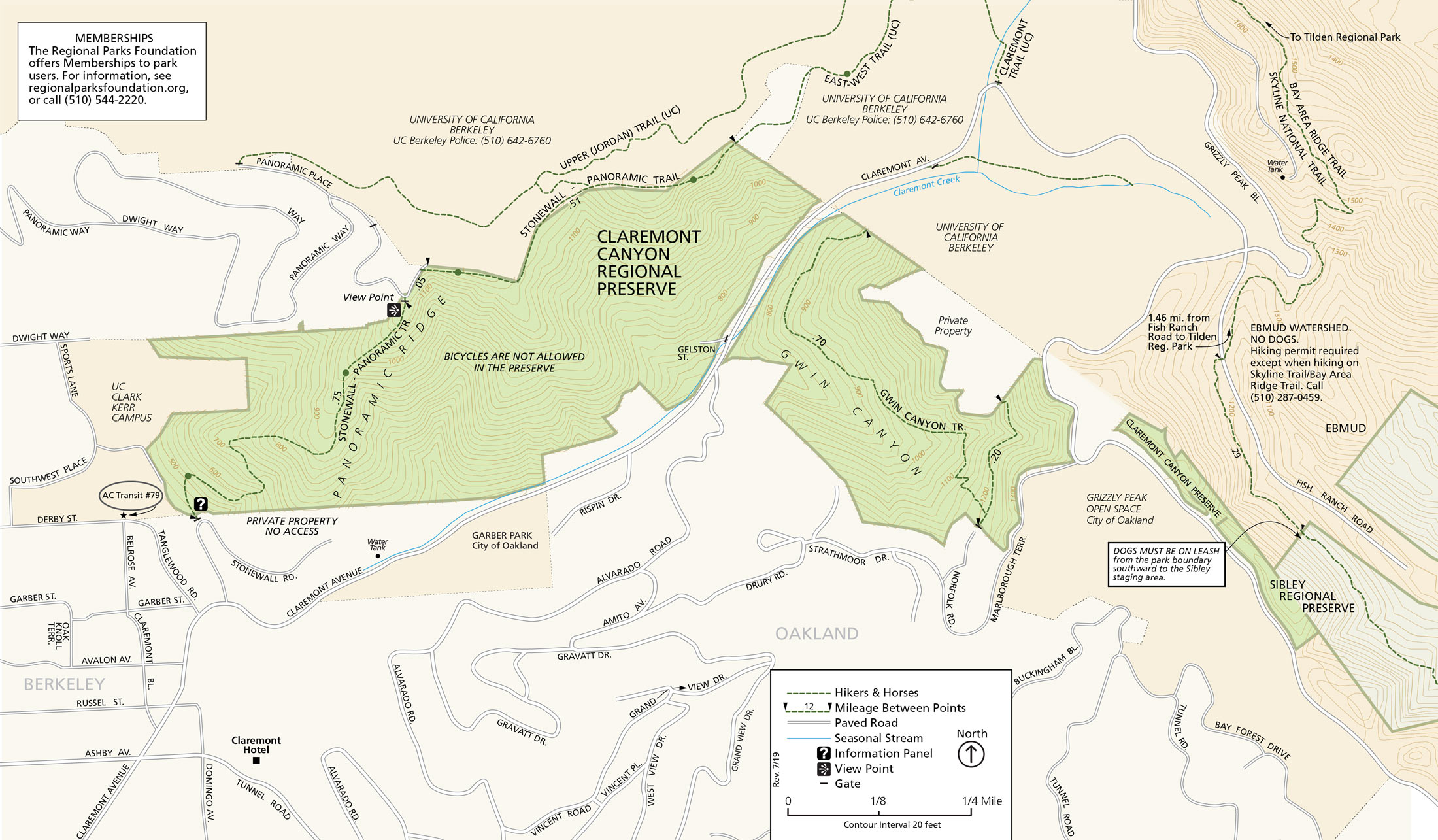
Claremont Canyon Regional Preserve is nestled in the Berkeley and Oakland hills behind the historic Claremont Hotel. This scenic, 208-acre preserve protects two parcels of land located on both sides of upper Claremont Avenue. Panoramic Ridge rises steeply to the north, and Gwin Canyon extends south. In addition to East Bay Regional Park District land holdings in Claremont Canyon, other undeveloped portions in the upper canyon are managed by the University of California and the East Bay Municipal Utility District. The City of Oakland owns Garber Park, a 13-acre oak/bay woodland south of Claremont Avenue.
To Reach The Park
Maps
Attractions
Hiking and Equestrian Trails
Claremont Canyon Regional Preserve is used primarily for its picturesque hiking trails. The Stonewall-Panoramic Trail is the primary access through the preserve. The .75-mile climb from Stonewall Road to the ridgetop is steep, but hikers are rewarded with a panoramic view of Oakland, Berkeley, San Francisco Bay, and the Golden Gate Bridge. The trail continues east along the ridge, straddling the boundary with University of California property, and connecting with the University's Ecological Study Area trail system.
Gwin Canyon Trail is a scenic, single-track hiking trail located south of Claremont Avenue. It descends from the north end of Norfolk Road and ends 0.6 miles from the trailhead, just above Claremont Creek. In Gwin Canyon, an array of native vegetation provides excellent habitat for wildlife, especially after previous fires swept through the area.
Upcoming Events
History
Claremont Canyon Regional Preserve was conceived in the 1970s through community activism that urged for the preservation of the Claremont Canyon watershed. The East Bay Regional Park District then made great efforts towards the preserve's creation. In 1978, the District first acquired 80 acres of surplus state property in the hills immediately east of the California School for the Deaf and Blind, which became the University of California's Clark Kerr Campus. The Park District later acquired land east of the state surplus property from many individual landowners. Completing the preserve, the District purchased a 64-acre parcel covering most of Gwin Canyon.
Cultural History
The first inhabitants of the region were the Huchiun Ohlone Indians. It is likely the Huchiun lived in an area ranging from present day Richmond in the north, to Oakland in the south, including Claremont Canyon. They traversed the landscape from their village sites near Temescal Creek and beyond, managing the land to meet their survival and social needs. The Huchiun used Claremont Canyon as a thoroughfare that connected them to valleys to the east, thereby creating the first imprints of a creekside trail.
Although today's Claremont Canyon was a part of the Spanish land grant Rancho San Antonio of 1820, the first recorded use of the canyon was by American settlers as an important communication and transportation route. In 1858, a transcontinental telegraph line that linked the west and east coasts was strung through Claremont Canyon, and the canyon became the main "highway" for horse and wagon traffic between Oakland and Contra Costa County. In the early 1860s, Pony Express riders carried mail along this route. Travel through the canyon declined after 1903 with the opening of the Kennedy Tunnel, which preceded the Caldecott Tunnel. In the early 20th century, Claremont Canyon was used for cattle grazing, dairying, minor quarrying, the development of springs, and for eucalyptus plantations.
Natural History
Claremont Canyon Regional Preserve is a part of an ecological corridor on an urban fringe. Claremont Canyon's 500-acre watershed, a mosaic of vegetation types from grasslands to coastal scrub and oak/bay woodland to eucalyptus plantations, supports a variety of animal species and plant communities. Commonly seen residents include black-tailed deer, coyote, gray fox, red-tailed hawk, and western terrestrial garter snake.
A 1.5-mile section of Claremont Creek, also known as Harwood Creek, flows through the center of the canyon. The creek was culverted in several places, altering its natural flow. Claremont Creek is one of the three main tributaries of Temescal Creek, which eventually drains into San Francisco Bay in Emeryville.
Fire is a natural process of the region's landscape, but uncontrolled wildfires have been a concern for city residents near Claremont Canyon. In the last century, four major wildfires have spread through the canyon, including the 1991 Oakland Hills Fire. Efforts currently underway to protect Claremont Canyon from the threat of uncontrolled wildfire include creating roadside fuel breaks and reducing non-native vegetation.